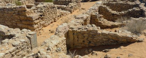
This page cannot be viewed in frames

Go to page

If you have found a spelling error, please, notify us by selecting that text and pressing Ctrl+Enter.

Articles (Geography)

The Roman state existed in practice for XIII centuries, being the power which was impacting the history. Therefore, I decided that I would tell the history of ancient Rome in the articles below, which will not necessarily cover only the Eternal City.

I encourage you to send articles and point out any corrections or inaccuracies.

Roman provinces in Asia Minor

When reading about events in the history of the Roman Empire, you sometimes come across geographical names that cannot be intuitively defined on the map of modern countries. Names of lands, such as: Pont, Bithynia, Cilicia, Phrygia, Galatia, Lydia, Pamphilia or Paflagonia are not to be found on the maps of contemporary school geographic atlases.

Location of the geographic lands of antiquity on the Asia Minor peninsula

Romans in the Baltic Sea?

The Baltic Sea is not far from the former theatre of Roman military campaigns and research expeditions. How did the Romans imagine its location and coastlines? Have they ever influenced the reservoir over which present Poland lies?

Classis Germanica

Embankment on Hadrian’s Wall

Hadrian’s Wall, Vallum Hadriani, is perhaps the most famous of the Roman limes. It was built in the years 121-129 CE and stretched 117 kilometres in the present-day village of Bowness on the Solway Firth to the Segedunum fortress (today it is Wallsend on Tyne).

Hadrian's Wall

One more secret of Petra

One of the most interesting – and possibly the most beautiful – cities of the Roman Empire was the former capital of the Nabataean Kingdom: Rakmu, better known as Petra. Incorporated into the empire during the reign of Trajan in 106 CE, it became the capital of the Arabia province and began to develop dynamically.

Tomb in Petra

Spelling error report

The following text will be sent to our editors: