Chapters
The Baltic Sea is not far from the former theatre of Roman military campaigns and research expeditions. How did the Romans imagine its location and coastlines? Have they ever influenced the reservoir over which present Poland lies?
It is a well-known fact that during the wars in Germania at the turn of the 1st century BCE and 1st century CE. The Romans operated their fleet in the North Sea. Although there is no evidence of this, it is also possible that the Roman navy entered the Baltic in the course of naval operations, supporting the land campaigns of the legions reaching the Elbe. Another clue pointing to possible research or military presence in the Baltic is the partial knowledge of the western part of its coast, noted by one of the first Roman geographers – Pomponius Mela, as well as an eminent scholar – Pliny the Elder.
The activity of the Roman fleet during the wars in Germania
During Roman expeditions to conquer Germania between the Rhine and the Elbe (Latin Germania Magna), the Roman navy operated in the North Sea. (Latin classis Germanica). Amisus (now Ems), Visurgis (now Vesera) and Albis (now the Elbe). It is also known that she participated in the climax of Roman expeditions in Germania – the Tiberius campaign in CE 5, which conquered all of central Germany as far as the Elbe. The operation of the fleet was coordinated with the land expedition of Tiberius, also operating on the Elbe. No historians have survived to prove that the Romans crossed the Danish Straits (Skagerrak, Kattegat, then the Sound or the Small or Big Belt) and entered the Baltic Sea. However, this seems to be very possible in the course of such extensive operations as were carried out by Roman leaders in Germania from 12 BCE to the defeat of Varus in 9 CE.
Knowledge of the Romans about the Baltic Sea
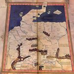
The Latin name of the Baltic Sea is Codanus Sinus. This ancient term was first mentioned by the geographer Pomponius Mela in his work De situ orbis libri tres. She appeared again in Natural History of Pliny the Elder. For these Roman scholars, it was a huge bay (sine in Latin is a bay, although the name is associated primarily with mathematics rather than geography) on the north coast of Germania with numerous islands on the other side of the Elbe. The largest island in this bay was to be called Codannovia. It was the Scandinavian Peninsula today. One of the first Roman geographers, Pomoponius Mela, was therefore convinced that the largest peninsula in Europe was only an island in a bay that was the Baltic Sea. The concept of Codanus Sinus in Pliny the Elder also included the waters of the Kattegat Strait, because he mentions the bay boundary by Cape Cymbry (it is today’s Cape Skagen – the northernmost point of the Jutland Peninsula) and the mountains called Saevo. The very origin of Codanus is unclear and the subject of many hypotheses. The most common ones derive from the Latin quoden, describing the rounded shape of the western and southern Baltic coasts.
Summary
The knowledge of the Romans about the Baltic Sea was not great, as evidenced by the inaccuracy of the geographical description of its coast. However, even to acquire such knowledge, the Romans had to get to know the shores of the Baltic Sea in one way or another on the occasion of subsequent campaigns in Germania. Hence, their presence in the Baltic Sea is highly probable, despite the lack of source information on this subject.


